Bradley Stoke - A Flourishing Community
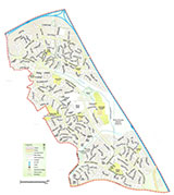
Bradley Stoke is a large development first planned in the 1970s. It comprises 1,000 acres (404.7 hectares) of land that incorporate 650 acres (263 hectares) for housing. One hundred acres (40.5 hectares) have been used for employment purposes and there are 180 acres (72.8 hectares) of major public open space. 1n 1984 the name 'Bradley Stoke' was chosen, deriving from Bradley Brook and Stoke Brook, which flow through the area. John Cope, then MP for Northavon, cut the first turf in March 1987 with a JCB excavator instead of the traditional spade. Bradley Stoke really began to take shape in 1988 with about 10% of the area in the north encompassing light industrial and commercial development.
The M5 to the north and the M4 to the east form two boundaries of Bradley Stoke. The more-or-less straight line of the B4057 (known as Winterbourne Road) forms the southern boundary where Bradley Stoke borders Stoke Gifford and the line of Orpheus and Braydon Avenues roughly forms the western boundary alongside Little Stoke and Patchway. The motorways (M4 and M5) were cut through the parish of Almondsbury in the 1960s and separated over 200 acres (81 hectares) from the main part of the ancient parish which now lies to the north of what is called the 'Almondsbury Interchange'.


The area of land in the north of Bradley Stoke that used to be part of Almondsbury parish now comprises about a fifth of the new parish of Bradley Stoke; there is also a small area of land that was once part of Patchway with the remainder coming in from Stoke Gifford. A tiny triangle of land in the bottom southeast corner of Bradley Stoke is now occupied by a factory was once in Winterbourne Parish.
Development of the new town began from the two ends of Bradley Stoke, with the construction of major residential areas to the south near Stoke Gifford and to the north near Almondsbury. Building from both ends in this way enabled the new houses to be reached from existing roads and obviated the need for the entire infrastructure to be in place before the housing developers could see a return on their investment. The town is now a mixture of properties - from one bedroomed flats to five bedroomed houses - and is an extremely popular place to live as it is close to local work opportunities at Aztec West and the Motorway networks. Only a few of the pre-1987 dwellings exist and these include a small hamlet in a road known as The Common (East), where Manor Farm used to be.


Bradley Stoke has almost 9,000 house and flats (8,653 dwellings – 2011 Census figures) giving a population of close to 21,000 (20,599 – 2011 Census figures) with 15,005 people on the February 2019 electoral roll. The town has eight schools (7 primary and 1 secondary), playing fields, local shops (including the Willow Brook Centre), Community Buildings and a variety of leisure services supporting the residents.
Much of the area that Bradley Stoke was built on was low-grade farmland, although a number of attractive natural features such as Savage's Wood, Webb's Wood and Sherbourne's Brake have been incorporated into the town and form the Three Brooks Local Nature Reserve. This is a tranquil area in the middle of the bustling community of Bradley Stoke and is made up of the three previously named bluebell woodlands, linked by an important wildlife corridor that includes brooks, ponds areas of rough grassland, species-rich hedgerows and a lake.
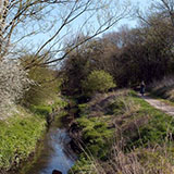


The rich mix of habitats provides a valuable place for wildlife to thrive. The area provides food and shelter to a wide range of wildlife, including reed buntings, skylarks, great crested newts and slow worms and a great place for local residents to walk or cycle through as the well-signposted network of cycle ways provides well-surfaced paths throughout the reserve for people to view the many different habitats. The nature reserve is cared for by local residents who have set up a conservation group (The Three Brooks Nature Conservation Group) that meets on the first Saturday of each month to help manage the reserve. The group organises a range of events and practical workdays to help raise awareness of the nature reserve and to enhance its biodiversity. These range from bat walks to traditional woodland management like coppicing and ditch clearing. The BTCV's (British Trust for Conservation Volunteers) have a 'green gym', that meets every Thursday between 10am and 1pm. The gym is a great way to get to know your local environment and meet like-minded people who wish to do their bit for their community whilst getting fitter at the same time.
Bradley Stoke, unlike many new housing areas, was planned on a largely self-standing basis, rather than as an extension to an existing community. In May 1990, Christine Lambert (University of Bristol) wrote:
"The concentration of new house building on a small number of large green-field sites is a distinctive feature of planning policy in Avon. It is in part a response to the politics of new house building (the political controversy generated by allocating sites for housing on the edge of small towns and villages) and also a response to the problem of providing infrastructure to support new development. The large-scale investment required of developers in roads and water supply particularly, is only feasible for very large-scale developments."
(Excerpt taken from 'New Housebuilding and the Development Industry in the Bristol Area' by Christine Lambert, School for Advanced Urban Studies - Working Paper 86, University of Bristol May 1990)